


Date: On Friday
Distance: 30nm
For this third day, the catamarans of Costarmoricaine return eastward for the longest leg of this long distance. It even happened in the past that it ends at nightfall due to lack of wind. There is also often an intermediate arrival at the Veille de Loguivy, to regroup the fleet. Although this is partly the track of the day before in the opposite direction, this course is usually carried downwind and you will have the opportunity to go relatively offshore while sailing to the Héaux-de-Bréhat. The regatta finishes at the foot of the cliffs of Plouha which are the highest of Brittany.
| # | Symb. | Description | Left on... | dprev(nm) | dtot(nm) | Coordinates | dtot(km) | Estimated time |
| 1 |  | Start line In front Trestraou beach. | 0.0 | 0.0 | 48° 49.964' N 3° 27.814' W(GP) | 0.0 | ||
| 2 |  | La Fronde Starboard side buoy | Starboard | 1.2 | 1.2 | 48° 49.867' N 3° 25.983' W(GP) | 2.2 | 11:00 - 11:40 |
| 3 |  | Pierre du Chenal Hazard tower | Port | 1.0 | 2.3 | 48° 49.283' N 3° 24.683' W(GP) | 4.2 | 11:10 - 11:50 |
| 4 |  | La Roche Guazer Port side buoy | Starboard | 3.4 | 5.6 | 48° 51.600' N 3° 20.967' W(GP) | 10.4 | 11:20 - 12:30 |
| 5 | | Basse Crublent Port side buoy | Starboard | 7.0 | 12.6 | 48° 54.267' N 3° 11.150' W(GP) | 23.4 | 12:00 - 14:00 |
| 6 |  | La Jument des Héaux North buoy | Starboard | 2.3 | 15.0 | 48° 55.333' N 3° 8.033' W(GP) | 27.7 | 12:10 - 14:20 |
| 7 |  | Les Héaux de Bréhat Lighthouse | Starboard | 2.1 | 17.0 | 48° 54.500' N 3° 5.183' W(GP) | 31.5 | 12:20 - 14:50 |
| 8 |  | La Moisie East mark tower | Starboard | 2.1 | 19.1 | 48° 53.833' N 3° 2.217' W(GP) | 35.3 | 12:30 - 15:10 |
| 9 |  | La Vieille du Tréou Starboard side tower | Starboard | 2.0 | 21.1 | 48° 52.000' N 3° 1.083' W(GP) | 39.0 | 12:40 - 15:40 |
| 10 |  | La Vieille de Loguivy West mark tower Gate with an organization boat. | Port | 3.0 | 24.1 | 48° 49.617' N 3° 3.850' W(GP) | 44.6 | 13:00 - 16:10 |
| 11 | | Cadenenou North buoy | Starboard | 3.2 | 27.2 | 48° 49.800' N 2° 59.067' W(GP) | 50.4 | 13:10 - 16:50 |
| 12 | | Men Gam East mark tower | Starboard | 0.3 | 27.6 | 48° 49.550' N 2° 58.750' W(GP) | 51.0 | 13:10 - 17:00 |
| 13 |  | La Cormorandière Tower | Starboard | 2.0 | 29.6 | 48° 48.200' N 2° 56.450' W(GP) | 54.8 | 13:20 - 17:20 |
| 14 | | Les Charpentiers East mark tower | Starboard | 0.4 | 30.0 | 48° 47.883' N 2° 56.017' W(GP) | 55.6 | 13:30 - 17:30 |
| 15 |  | Les Calemarguiers East buoy | Starboard | 1.2 | 31.2 | 48° 46.983' N 2° 54.850' W(GP) | 57.8 | 13:30 - 17:40 |
| 16 | | Basse St Brieuc East buoy | Starboard | 1.0 | 32.3 | 48° 46.250' N 2° 53.717' W(GP) | 59.7 | 13:40 - 17:50 |
| 17 | | Le Taureau Hazard tower Gate with an organization boat. | Port | 2.9 | 35.1 | 48° 43.550' N 2° 55.250' W(GP) | 65.1 | 13:50 - 18:30 |
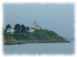
| 18 | | Île Harbour Lighthouse | Port | 5.7 | 40.8 | 48° 40.000' N 2° 48.500' W(GP) | 75.7 | 14:20 - 19:40 |
| 19 | | Finish line East mark tower In front of Countess' beach, between East tower Les Moulières de Portrieux and a boat showing an orange flag. | 0.9 | 41.7 | 48° 39.250' N 2° 49.215' W(GP) | 77.3 | 14:20 - 19:50 |
Warning:Provided geographical coordinates may contain errors, we disclaim any liability in this case. Furthermore, there are obstacles to navigation between some consecutive marks so you must prepare your navigation by carefully referring to a marine navigation chart.
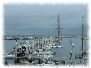
Located in front of Harbor Island, and its small lighthouse, the town of Saint-Quay-Portrieux is known for its marina in deep waters. We will stop next door, on the beach of the Countess, and enjoy the facilities of the port. This port regularly hosts match-racing competitions.
Useful links:
Tourist Office: http://www.saintquayportrieux.com/
Club de Voile de la Baie d'Erquy - Maison de la Mer - 22430 Erquy - France - Copy not allowed - CGV - About us - Updated on: 13/06/2022 00:05 CET